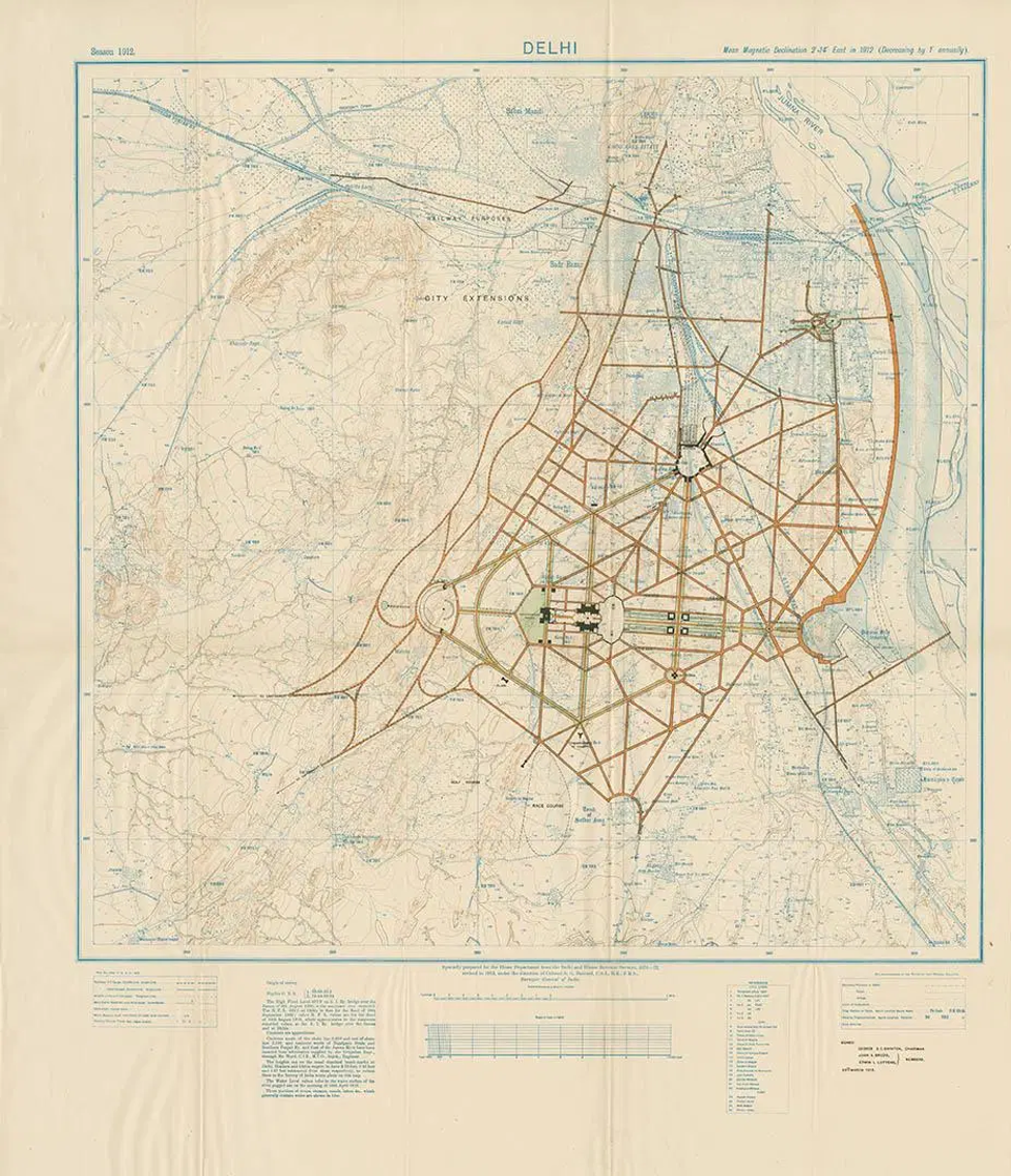
In 1912, it was decided by an English government, the words formed so perfectly by an English tongue, that the capital of British India be moved from Calcutta on the Bay of Bengal to Delhi, at the heart of the subcontinent. Though Dilli had existed for millennia as the jewel of the Mughal dynasty, the Indraprastha of the Mahābhārata, it was to be recut in Her Majesty’s own image. A new map of an old city was fashioned; architects employed in the service of the Empire descended upon Delhi, bringing with them a lavish enthusiasm for the map as a method of cultural production and destruction. Their pen would subjugate India’s traditional seat of power in the making of an ideology of the Raj and its sublime dominion: for “there [could be] no obstruction to the free planning of an ideal city”.1 These notions are reflected in “Edwin Lutyens’s official master plan for the creation of New Delhi”, published in 1913, and would guide the development of the legislative sector of the imperial capital until its completion and formal inauguration eighteen years thereafter.
In its ordered boulevards, excluded buildings, its bungalows and its durbars, Lutyens’ vision infects the city like a virus, spreading in axial direction as an imposition of the colonial identity and a sublimation of the indigenous. Its proposed lines are thick and bold, so strong in red; juxtaposed with the fading edifices of destitute ruins, as washed out as the river Yamuna upon which they rest, and emasculated in palest blue. Where river ends and (un)civilization begins is of scant concern to the imperial eye. Rather, it is the new formulation of an Indic future which attracts the gaze. Lutyens chooses his city carefully, subsuming and appropriating the extant symbols where apposite. India is the land of gods and kings, so the ‘Lord Sahib’ deliberately entraps and encircles the numinous and the royal – see the intersections with Safdarjung’s Tomb, the connections to Jama Masjid and Humayun’s Tomb, the vestigial organs of the Purana Qila and Indrapat. The strategic identification of alternate authorities leads to a systematic disembowelment of the spiritual body: a legend in the bottom left corner subordinates “temples, mosques, tombs, satis, idgahs, and graves” alike. Britain’s “battle of science and faith” would pit the once and future capital against “association and sentiment”, reifying the new and the “clean” against the existing “dirty architectural slate”.2
The map, clotted in blossoming hexagonal menaces, orders and regulates India’s naturally diffuse zones. Modernity was to be brought to the Indians, but not for them. Inked in black, for example, lies space for a railway station – that civilizing angel embodied in steam. Undoubtedly, the products of the rail’s ‘commerce’ would have been shipped off to the ports of Bombay or the Carnatic coast, destined eventually for Mombasa or Singapore or London itself. 1912 hypostatized the colonial imaginary, becoming a temporal marker in the history and spatiality of the city. Delhi could be divided into a before and an after, for Lutyens and his ilk came as conquerors on sun-drenched soil. The power and might of Britannic architecture would dominate the skyline, rising above the verdant greens and wild forests, the bazaars and the dirt that resided therein. New Delhi, in its stilted legislature and its grand secretariat buildings, would come to inescapably dramatize “human control over the world stage” and the linkages of Britain’s splendid transcontinental Empire, celebrating the winsome glory of the British race.3
Of course, in 1912, seven years before the massacre at Jallianwalabagh, eighteen years before the Mahatma drew salt from Dandi,4 this map did not depict what was; but rather, what was to be, and what was to come for a decidedly British India. It put forth an argument of the nature and character of the universe, in the same way the divine maps of Medieval Europe conceived the sacred and the mundane along the global gradients of time, space, and geology. Indeed, the quadripartite plans of water gardens in Lutyens’ Delhi were said to have similarly figured in “Muslim conceptions of paradise, Hebrew visions of Eden, and the Hindu mythological geography of the world”.5 The reinvention of Delhi via survey collates the arrogance and self-righteousness of the British colonial experience – for in bringing one vista of civilization, the exponents of that island-abode deigned to subvert another.
The story of the map of Delhi is a story of the nodes and nexuses of mapping power. The map’s principles of architecture and design wished to portend a thousand more years of Britain’s brilliant sun over India’s vital dusk. The buildings Lutyens has manifest on paper, his orientation of a New Delhi over and upon the old, are made so as to protect the Raj’s white skin from what he named the “tremendous violence” of India’s climate, even as its habitus legitimated a great violence of its own.6 His structures sit elevated as a virtual acropolis atop Raisina Hill – what Alexander of Macedon haltered to realize at the Hydaspes, Lutyens and his apostles managed to accomplish at the Yamuna in all its proper resplendence. Even so, 1931 and the completion of the imperial capital marked the start of the end, prophesying the final intensification and unravelling of British authority over India. Perhaps the sight of “fairytale palaces” and “castles in the air come true” became an intolerable symbol of lordship and injustice that even the most wretched of the earth could no longer bear.7 By 1947, the Bastille had been stormed; Lutyens’ Delhi and all its futures were to be repatriated to the Independent and democratic government of India. And to this day, the tiles of Connaught Place and the streets of New Delhi are still whiter, and cleaner, and more orderly than the fantastic, autochthonous mess that abounds around it.
Anvesh Jain is a student pursuing an Honours Bachelor of Arts at the University of Toronto – St. George, with a specialization in International Relations. He is actively involved both on and off campus in Toronto, as well as back home in Calgary, Alberta. Anvesh has worked as a Constituency Assistant in the Parliamentary Riding of Calgary Forest Lawn, and as a Program Editor for the NATO Association of Canada. His research interests include topics in Canadian and South Asian international relations, with particular regard for questions of grand strategy and diplomatic history. His work has been published by the Mackenzie Institute and the Literary Review of Canada, and he is an avid follower and player of Cricket.
Bibliography
Baker, Herbert. “The New Delhi.” Journal of the Royal Society of Arts 74, no. 3841 (1926): 773-93.
Irving, Robert Grant. “Architecture for Empire’s Sake: Lutyens’s Palace for Delhi.” Perspecta 18 (1982): 7-23.
Lutyens, Edwin Landseer. “Edwin Lutyens’s official master plan for the creation of New Delhi.” Accessed online through the Kalakriti Archives. Originally published as a Chromolithograph by the Surveyor General’s Office, Culcutta, 1913. https://artsandculture.google.com/asset/new-delhi-edwin-landseer-lutyens/5AGDmuMaU5Nxsg
National Portal of India. “Freedom Struggle.” Accessed February 12, 2020. https://knowindia.gov.in/culture-and-heritage/freedom-struggle/the-non-cooperation-movement.php.
Thomas, Maria. “A beautiful collection of rare maps shows how the world viewed India over the centuries.” Quartz India, April 11, 2018. https://qz.com/india/1245549/kalakriti-archives-rare-maps-reveal-how-indias-cartography-evolved-over-centuries/
Footnotes
- Herbert Baker, “The New Delhi”, Journal of the Royal Society of Arts, 74, no. 3841 (1926): 774.
- Ibid., 773.
- Robert G. Irving, “Architecture for Empire’s Sake: Lutyens’ Palace for Delhi,” Perspecta 18 (1982): 14.
- “Freedom Struggle,” National Portal of India, https://knowindia.gov.in/culture-and-heritage/freedom-struggle/the-non-cooperation-movement.php.
- Ibid., 20.
- Ibid.,10.
- “Ibid., 9.


